The Landsker: lines across a landscape
Across the world, there are many examples of places that, for one reason or another, are separated by a north-south divide. Few, however, are as longstanding or as entrenched as the one in West Wales, particularly where it draws a line across the entire width of Pembrokeshire.
The Landsker Line, which runs roughly west to east from the coast at Newgale through Wiston and on to Narberth before crossing the border into Carmarthenshire and continuing on to Laugharne, has existed since the first half of the 12th century and separates the Little England Beyond Wales of south Pembrokeshire with the more traditionally Welsh north of the county.
The Landsker – the word is believed to originate either from ancient Norse for a divide or a word of similar meaning from the Old English dialects of Devon and Cornwall – separates the two parts of the county both linguistically and culturally and is as meaningful to the region’s history as Hadrian’s Wall or Offa’s Dyke are to the Scottish-English and Welsh-English borders.
Although there are no signposts anywhere and many might not even know of its existence, the impact of the Landsker Line remains almost as clear today as it did some 800 years ago, and while it may have edged a few miles north or south over the subsequent centuries, the divisions it created still exist, with the vast majority of those living south of the line either monolingual or predominantly English speakers, while to the north, Welsh is still a thriving, living language, spoken by many during the day-to-day business of life.
The origins of the Landsker can, perhaps surprisingly, be dated quite specifically to a series of deadly storms that battered the coast – not of Wales, but continental Europe almost a millennia ago.
The winds and rain that devastated the coast of low-lying Flanders – modern-day Belgium – in 1106 left much of the surrounding countryside under water, driving the Flemish natives into homelessness and poverty.
The hardship led many to seek sanctuary across the sea in Britain under the protection of Henry I, whose mother was Matilda of Flanders.
The King welcomed these newcomers and encouraged them to settle around Rhos on the banks of the River Cleddau in the far west of Wales. The growth of the Flemish enclave in Pembrokeshire continued under the reign of Henry’s grandson, Henry II.
During these years, the settlers and their protectors – the Norman kings of England – sought to drive the indigenous Welsh out of the rich, fertile lands of the southern parts of the county and pushed them north into the less forgiving, rocky landscapes of the Preseli Hills.
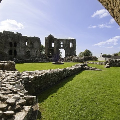
To secure their claim on the south, the Normans and Flemish began construction of a series of strongholds – castles, forts and earthworks – which would ultimately provide the links of the chain that would become the Landsker Line we know today.
The Line followed field boundaries and landscape features between the castles, most notably from Roch to the sea where Brandy Brook, the small river that empties into St Bride’s Bay at Newgale, is recognised the marker between north and south of the Landsker.
Many of the frontier castles – or in places, their ruins – remain to this day and can still be seen at Roch, Wiston, Llawhaden, Narberth and at Laugharne. Haverfordwest castle was built by the Flemish leader Tancred soon after his arrival in west Wales. Meanwhile, the fortifications at Tenby – the castle and its walls – were also built by the Flemish during the same period.
Prior to the Norman invasion of Britain and the arrival of the Flemish, the whole of Pembrokeshire would have been predominantly Welsh-speaking, but the influx of the settlers saw the language all but eradicated in the south of the county throughout the Middle Ages.
However, while English became the primary language of south Pembrokeshire, it’s remoteness from England ensured that for generations the language and accent of the region diverged from the rest of England with many words and phrases remaining in use hundreds of years after dying out elsewhere.
No one seems to be entirely sure when the description of Little England Beyond Wales first came into use, but the Anglicisation of south Pembrokeshire – and its separation from the north of the county – continued long after the castles were built.
Throughout the centuries, north Pembrokeshire – like much of the rest of Wales – became a hotbed of Non-Conformism while south of the Landsker, Anglican or Catholicism remained the main religions. This divergence can still be witnessed today thanks to the large number of chapels found north of the divide compared to those in the south.
The place-names of Pembrokeshire also illustrate the divide, with the vast majority of villages and hamlets to the north bearing Welsh names while to the south English place-names or those of Flemish origin are much more common – it is as hard to imagine a Johnston or a Honeyborough north of the Landsker as it is a Eglwyswrw or a Mynachlog-ddu below it.